A recent back road trip led me to discover the current progress of the provincial government in trying to mitigate an inherited contaminated area. If ignored, it would become a long-term catastrophe.
It’s called a lake, Steep Rock Lake, but it isn’t, really.
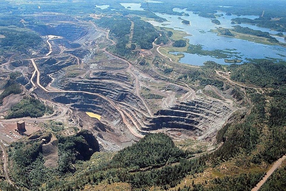
It now looks a little like the setting of a Waubgeshig Rice dystopian novel or Last of Us the raging HBO hit.
There are cautionary and explanatory signs and fenced off areas everywhere. Over time the former asphalt access roads are now well pitted and cracked with emerging plants. The same with the railway over/underpasses. The original galvanized guard rails are coated with a tinge of red iron ore dust.
I'll need a car wash after driving around the circle route around the entire affected area. It’s about a 15km drive through what was. There is no industrial noise of a working mine present but there are reminders of ghosts. Overgrown railway ties and rails still remain showing the former progress of moving iron ore, slabs of concrete foundations of buildings past.
There is a ground base of pulverized Canadian Shield waste rock throughout, this created the original working site plan. The vegetation is stunted and dense like after the regrowth of a wildfire. And don’t let the inviting Caribbean aqua marine colour of the open mine pits’ rising water fool you. The past impact makes the landscape look bleak, there’s no lushness here.
Setting
In some environmental circumstances the past catches up with the present and then predicts the future. This story is a not so well-known calamity on the back roads - with a pending solution.
The process to success is almost a lifetime away, but the Ministry of Natural Resources (MNR) is determining the best way to control water that will eventually overflow three open pit mines in northwestern Ontario. The estimated cost for mitigation will approach one billion dollars, or more.
During its heyday more rock was taken out of these pits when compared to the construction of the Panama Canal.
A mitigation plan for the Steep Rock pits has been a long time coming and the legacy mine's rehabilitation is going to unfold over a very long period.
The conceptual mitigation approaches that have been put forward will serve to improve water quality over time, to a point where it can be released into the adjacent waterbodies, around 2070. Potable water is the end goal.
The Caland and Steep Rock mines are about three kilometres north of Atikokan, Ont. Two of the open pits, the Caland and Hogarth, require attention before water flows out of the former mining site. Water in the Caland pit is deemed to be of fairly high quality, while the Hogarth pit is contaminated with mining waste.
The projection is, as the water continues to fill the pits, will start to overflow in about 40-plus years. About one kilometre of secondary highway #622 connecting Highways 17 (to the north) and 11 (to the south) will be flooded and will need to be rerouted.
The conceptual approaches that have been put forward will serve to mitigate contamination to a point where it can be released into the adjacent waterbodies, around 2070 (+-).
How it started
Back in the day it was a different story. There was a need for the iron ore. At the time it was the richest undeveloped deposit of hematite iron ore on the North American continent.
This newspaper clip sets the scene.
From the Vancouver Daily Province newspaper, May 18, 1940, Fishing for Iron – To Win Canada's War, by James Montagnes:
Any day now they'll be bringing up the first load of iron ore from below the bottom of Canada's Steep Rock Lake, reputedly this country's largest and richest iron ore field yet discovered.
For the last several winters, men have been exploring the frozen region of Ontario's M-shaped Steep Rock Lake, 135 miles west of Lake Superior's Port Arthur and 30 miles north of the Minnesota border.
Now shafts are being sunk deep beneath the lake's clay bed. And it is expected that, before the end of the year, 750,000 tons of ore – a third of Canada's ore imports from the United States and Newfoundland last year – will have been taken out.
Canada needs that iron ore now – needs it worse than she has since the last war. There are cannon to be made quickly. And rifles, tanks, ammunition, ships – all the materials of war. During the last war Canada imported eight million tons of iron ore.
It was always hurry on that lake ice last winter and the winter before. No dawdling, no time for discussing the weather.
Out on that ice-covered lake the men were fishing – not for fish but for a bigger prize. They were fishing for new industries, new cities. They were hunting for iron ore, for enough iron ore to cut
Canada's imports of that product in half. For enough iron ore to help with the war against Germany…
This meant the lake had to be drained and all of the underwater silt and boulder overburden removed so as to get at the valuable and high grade hematite ore.
Mega project
The map will help for past and future orientation. The details of site preparation will help to understand this mega project.
It was not easy in the beginning, a lake had to be entirely drained. There was a glitch, the engineers said the water level of Finlayson Lake was too high so the Seine River could not drain into it.
To access the ore body, the river was diverted to drain the middle and east arms of Steep Rock Lake. This allowed for the removal of up to 100 m of glacial sediment from the drained lake bottom. In total, 260 million m3 of sediment was dredged (see the winter photos of dredging). By comparison, this volume of material is greater than that moved during the construction of the original Panama Canal.
To accomplish this colossal feat it required the construction of dams to isolate the portion of the lake in which the ore bodies lay, the diversion of the Seine River around the lake through the man-made esker Cut, a series of rock and gravel cuts, the elimination of a hydro-electric powerhouse, and finally the pumping out of Steep Rock Lake to reach the ore. This short description of what had to be done, allows for the mega understanding.
It was a past engineering marvel of enormous magnitude and complex environmental logistics. Steep Rock Lake was sectioned into three ‘arms’ by dams: Lake A, B (largest ore deposit) and C. Pumping out of more than 80 billion gallons of water from Lake B began in December 1943 with 14 electrically-driven centrifugal pumps, mounted on barges, draining out 300,000 cubic feet a minute. To run the electrical equipment, 10,000 H.P. of electrical energy was brought in by construction of power lines 142 (288 km) miles away.
The project required a huge water diversion and management including the construction of 40 water control structures including 14 dams and three tunnels, and the dredging of 210 million cubic metres of soft lake bottom sediments to expose the iron ore. In 1943, a plug is blown at the bottom of Finlayson Lake which led into a tunnel connecting to the Seine River to lower the water level in Finlayson.
Three dams were immediately constructed and the first pumps were put into action in the middle arm of Steep Rock Lake to dewater that section. By May of 1943, the water level had dropped 75 ft. Raft Lake (situated between Finlayson and Marmion Lake) was also lowered to connect the two larger lakes together to complete the diversion plan. All through the summer and winter of 1943, millions of tons of rock, gravel and earth were moved. More than a million cubic yards of rock had to be removed to create the canal between Raft Lake and Finlayson. When completed, it was six football fields long, a hundred feet wide, and as much as ninety feet deep in places.
Both Raft and Finlayson Lakes had been drained to the required levels, dams were built-including the dam between Marmion Lake and Raft Lake known as the Raft Lake Dam- and the cuts and canals had been completed. On January 28, 1944, the Raft Lake and Finlayson Diversion cuts were blown, which rerouted the water flow away from Steep Rock Lake. The lake was finally an isolated body of water and the job of pumping and mining the lake bottom could begin. In essence, they redirected the water flow.
The Steep Rock range was brought into production in 1945. Ultimately Atikokan grew to 7,000 people; in 2021 it is now 2,642. The community required access by road to the outside world. Thus, Steep Rock Iron Mines Limited was in effect responsible for the building of a road which would connect Atikokan, to the east and Shebandowan, which in turn was connected to the Trans-Canada highway (Highway 11) by a winding bush road. This allowed Port Arthur’s (nport handling capabilities to what would become Thunder Bay. Good times ensued for the community for more than thirty-five years.
The mining operations closed in 1979 and 1980, and there was no mine closure plan, so the company walked away. The property was assumed by the Crown in 1988 and has been monitored by the MNR since 2003, with work taking place in the last handful of years to stabilize the massive open pit area.
In 2018, the Ministry created a new overflow pipe through the Fairweather Dam, with work on the downstream drainage area into the 2020s. The decommissioning and removal of an existing 1.5-kilometre pipe between Fairweather Lake and the upper discharge pond took place in 2019. In essence, the province has been forced to inherit the past and be creative to seek an extended solution.
MNR solution
For the near past, present and future the abandoned mine pits are slowly filling with water and eventually will affect water control structures and developments in the mine area.
The water will be moderately contaminated by metals and sulphates, and other environmental issues identified at the site including unstable rock walls, large stockpiles of mine waste, abandoned transportation corridors and soil contamination.
The major, future issue of releasing water from open pits into the environment, is the impact on water levels. The Ministry has determined where the water will flow, and how it will get there, but water quality remains a concern. Once again history repeats itself, and the water will be redirected.
Recently from Sarah Fig of the MNR: “The Ministry has made considerable progress towards rehabilitating the former Atikokan mine site. We have a dedicated team that's actively addressing urgent safety issues by clearing away old mining structures and monitoring the dam and water quality in the project area.” The program has a theme of “Enhanced Natural Recovery.”
Over the last several years, the ministry has closely monitored and studied the site to plan its cleanup efforts. This involved analyzing the condition of the soil, plants, and water.
One measure will be to fill pit lakes to dilute concentrations and enhance existing stratification in the pit lakes, and also to accelerate the cover of existing mine waste with water.
Part of the 'enhanced' portion of the water treatment includes adding materials to the water, to help move any toxins to the lower levels of the mine.
The current plan would see the nutrients spread across the near-surface of the pit lakes on an annual basis, and for several years. The exact intensity and duration of the addition will require additional studies.
The primary focus at the former Atikokan mine site is the Caland Euclid area. The ministry has prioritized the upkeep of dam infrastructure on the site to ensure it meets regulatory standards through ongoing rehabilitation efforts.
Ontario has invested about $25 million towards restoring the site so far. “With our continued efforts and support from the Ministry of Mines under Minister George Pirie, restoration of this site remains a long-term commitment.”
“Meanwhile, we are also taking steps to improve pit lake water quality before the pit lakes overflow back into the surrounding environment. By doing so, the ministry hopes to protect local fisheries, wildlife heath and biodiversity.”
In addition about a one kilometre section of Highway 622 will eventually be flooded, as the pits spill over. An additional study will be required to determine the best, the most cost effective way of rebuilding or relocating that highway. Of all of this is a work in progress.
I reached out to the current Mayor of Atikokan Rob Ferguson.
“As the pits fill the water quality ‘lense’ becomes cleaner and cleaner. MNR modelling predicts once the pits fill, the discharge will be drinking water quality and may not require some sort of water treatment facility,” Ferguson said.
“Clean water will eventually be released but it will be decades before that happens. Highway 622 will eventually be underwater but that will happen around 2070.”
As an update, “The furrowing of contaminated soil project is delayed another year as they (MNR) had to change course. Currently the plan is to remove hundreds of truckloads and take them to a willing repository.”
The mine’s past economic impact was significant; but, as for now?
“We are hoping the contractors and MNR use some local contractors as well as support our economy with lodging, fuel, etc… The community is looking forward to the rehab from both an environmental and economic standpoint.”
Have a look
For extensive photos of the history of Steeprock go to the mining tab on Charles Dube’s Atikokan site. The creation of the original pits is worthy of a look.
He started the website 20 years ago.
“The mess left behind by the original mining company is upsetting by modern 'city' standards but is quite normal for the Canadian mining industry," Dube writes on the site. "They have a legacy of digging out the ore and leaving a toxic mess which they never had the slightest intention of cleaning up.”
The current estimate looking forward to a sequential solution for Steeprock is approximately $800 million, most likely this will increase astronomically.
Things are somewhat different now under Ontario’s Mining Act changed in 1990 requiring mines to now have mine closure plans and bonds to implement such plans. It is found under Part VII – Rehabilitation and Remediation of Lands. Under the Act the minister now has a great deal to say with regards to this.
MiningWatch Canada works in solidarity with Indigenous peoples and non-Indigenous communities who are dealing with potential or actual industrial mining operations that affect their lives and territories, or with the legacy of closed mines, as well as with mineworkers and former workers seeking safe working conditions and fair treatment.
“My perspective on this would follow a few different threads. One is the importance of designing for closure as well as progressive closure so that mines are built in a way that they can be decommissioned to a safe and stable state, and operated in a way that doesn't foreclose on closure plans or options, and moves progressively towards closure so that the work is not all put off to the end of operations," said MiningWatch Canada spokesperson Jamie Kneen of the Steeprock legacy.
“This is now industry best practice, but it's not necessarily put into practice, and Ontario seems pretty relaxed about pushing companies in this direction. The problem is that closure plans are only subject to technical review by the ministry, and it's now the minister who signs off on such stuff, not the Director of Mine Rehabilitation. There's more, of course, in the new Building More Mines Act.”
“We had a pretty weak regulatory regime for mine closure before, and it's significantly worse now,” he added.
A similar situation of magnitude occurs in Timmins with the Kam Kotia cleanup of an ugly swamp of acid-infused water locked between Highway 576 and the former copper mine’s remains on a ridge of rock.
There will be millions and millions dollars more spent to re-engineer what was. This non-fiction story encompasses the auspicious past of a needed mine, that morphed into a massive, present environmental challenge, this fix has to lead to a better future on the back roads.


