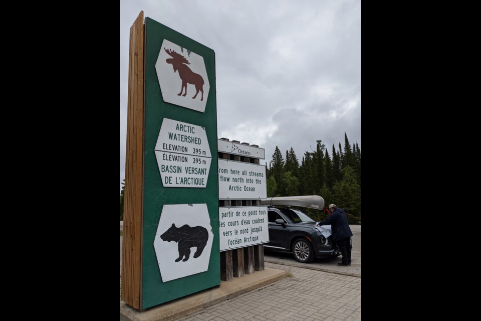
You’re headed to your next back roads adventure and you see those distinctive green and white highway signs announcing the water flows in different directions. Strange thing though there’s never any water by the signs. . .
There is a moose and a bear figurine and an elevation number. On one side it says the water flows to the Atlantic Ocean and on the other to the Arctic. What’s that all about?
It’s a line alright. There are personal and physical boundary lines; some are well demarcated, some are invisible. Sometimes these lines indicate physical features or reflect the social limits of peoples.
A “height of land” is a region of high ground that may act as a watershed boundary. Heights of land were important in the historic fur trade for their influence on the determination of routes and portages and they have affected many transportation routes since then. Drainage boundaries were important to Indigenous peoples in defining territoriality, as they were later to European colonists.
It is a line that traverses Northern Ontario. The height of land line follows an irregular course of some 2,250 kilometres across Ontario, ranging from 32 to 280km north of Lakes Huron and Superior.
The Ministry of Transportation, Northeastern Region provided some background. The highway signs were installed to complement the installation of Ontario Heritage Plaques near Kenogami, just north of Kirkland Lake. On Wednesday, Aug. 20, 1969 a provincial historical plaque marking the Arctic Watershed was unveiled beside Highway 11, about 14 kilometres (9 miles) northwest of Kenogami Lake, in the District of Timiskaming.
The Laurentian Divide or Northern Divide is a continental divide in North America dividing the direction of water flow in eastern and southern Canada and the northern Midwestern United States. Water north of the height of land flows by rivers to Hudson and James Bays or directly to the Arctic. Water south of the divide makes its way to the Atlantic Ocean by a variety of streams, including the Great Lakes and Saint Lawrence River to the east, and the Mississippi River to the Gulf of Mexico to the south.
Larry Dyke is a professor emeritus from Queen’s University, Department of Geology and recently retired from Natural Resources Canada. He is a geologist. He explained the most rugged and fragmented surfaces occur in a band extending from the north shore of Lake Superior, across the Algoma highlands, through the Sudbury region and north of Manitoulin Island.
It is here we find the two of the highest points of elevation in Ontario. One is Ishpatina Ridge, at an estimated 693 m (2,274’) above sea level within Evelyn-Smoothwater Provincial Park. Nearby Maple Mountain to the east, is often mistaken as being the highest point in Ontario, however it is actually lower on the list, but has the highest vertical rise in the province; 351m (1,152 feet) on the landscape.
“At a close-up scale there are so many subtle influences on the shape of those lines, especially in flat country. Thinking of the grain in a piece of wood, a slightly different cut may give a very different pattern. A slight bevelling of the landscape will move a drainage boundary kilometers.”
This oscillating line then is very important to Canadian history. In 1986, Nipissing University (then college) Professor Robert J. Surtees, of North Bay (now deceased; the physical education complex is named in his honour), in a Treaty Research Report for Indian and Northern Affairs Canada wrote, “ . . . in 1791 the boundaries of Upper Canada were set and the new colony received jurisdiction over the territory west of the Ottawa River between the St. Lawrence River and the Great Lakes waterway and the lands that had been granted to the Hudson Bay Company. Therefore the Upper Canadian boundary was demarcated by the height of land . . . This is significant for it meant that virtually the entire province was within Indian land as defined by the Royal Proclamation of Oct. 7, 1763 which decreed therein were reserved “for the Use of the . . . Indians as their Hunting Grounds (sic).” In essence, further land purchases and treaties were developed to alienate Indian title to the land.
The other signs are on Highway 144 near Gogama; also south of Chapleau on Highway 129. In Northwestern Ontario there are signs on Highway 11 near Geraldton and on Highway 17 near Raith, east of Atikokan. You don’t need a passport to cross this boundary. Stop and take a photo. The Atlantic and Arctic Oceans are far away. You are standing next to the sign still wondering which way the water is flowing?
