Road trip.
This is what happens when you don’t take a winter vacation to a destination anywhere within the “Gulf of America.”
Your mind wanders and wonders about what’s next to underline you are a true Canadian – especially during these times when a rise of Canadianism underlines our 158-year sovereignty.
What does being a Canadian mean anyway? Wearing mittens and a toque, snowshoes, canoes, back bacon and Bob and Doug McKenzie, maple syrup, poutine - the vanishing Hudson Bay blanket? There are many recognizable symbols to interpret.
The Wapusk Trail then becomes more than a random thought, it becomes cultural and personal, it is why we are shopping made in Canada and planning trips on our own back roads.
For some, braggin’ rights is a winter road that starts in Gillam, Manitoba, where the all-season Provincial Road 280, from Thompson ends.
At 752 kilometres (467 mi) in length, one way, this access is the longest seasonal road in the entire world. For about five weeks the winter road is a lifeline to remote communities isolated with only air access.
The Wapusk Trail is rebuilt every year out of packing and dragging snow, from Gillam eastward first, to Shamattawa, Manitoba, then a very long segment to Wasaho Cree Nation-Fort Severn, the province’s most northern settlement. You cross a provincial border, no sign, with no apparent tariffs and a time zone. The Arctic Ocean is reached on the Hudson Bay coast.
It then curves slightly south, but still east, inland through the expansive Polar Bear Provincial Park, along the coast to Peawanuck, about 30 kilometres inland on the Winisk River, the terminus and the beginning. As it is a linear adventure you have to do twice. There’s a chance to see polar bears again.
That’s the concept of the next challenge.
I reached out to my Frank and Joe Hardy sidekick, Brian Emblin (Chet Morton) of Timmins – he’s in, like always, and the planning begins.
Getting there
It is a vehicle trek requiring a vehicle with clearance as driving and winter conditions will change.
Emergency equipment is needed in case you are stranded en route including food and shovels and the necessary satellite communication as it is remote. Cell service ends in Gillam.
Weather dictates how long this seasonal road stays open so time is of the essence.
Part of the challenge is making your way to Wapusk (Cree- white bear) trail. Yes, Canada is indeed the second-largest country in the world by total area, after Russia.
From Timmins, it is northwest through Thunder Bay and Kenora, crossing into Manitoba…Winnipeg and then north to Thompson, Manitoba – another nickel mining community and then eastward to Gillam.
We leave on Tuesday, March 5, at 5:32 a.m.
It will be an education – a moving classroom like no other.
Although I've done this stretch of Highway 11 many times, it's never too familiar.
I always like the Moonbeam alien spaceship icon but there’s no longer a black bear in Kap and we must stop for a pic of the wolves and the moose in Hearst.
The iconic moose and wolf pack statues were sculpted from a sketch done by Real Gagnon, in Quebec and then transported by flatbed truck in the summer of 2002 to Hearst where they now rest at the Hearst Tourism Centre at the east end of town. In the information centre, there is a small furbearer display, including a wolverine, that will become a bit of foreshadowing.
Then there’s this well-known stretch of nothing much between Hearst and Longlac. Yes, you gas up no matter what.
It is mid-morning and we need some levity. We can’t count utility poles as there are none for more than 100 km. So it will be vehicles headed east. In the end, after almost 175 km (9:02 a.m. to 10:46 a.m.) we count 61 trucks, most of the tractors are white, six pickups and six cars, no OPP. Eventually, we do see poles there are too many to count though. There are lots of pull-off pulpwood load check areas for the logging trucks with those steel pickets that safely keep in the logs and double trailer chip vans. Snow conditions really vary along this stretch.
As the situation would have it, there’s the posting of tourism photos on social media. We play the guessing game and ask followers where we are going. The west coast…Fort McMurray etc…no clues about the Wapusk Trail.
Time for musings. We talk a lot about Mark Carney and we wonder if Trump, because of his gender leanings, respectively stated, will rename the Trans Canada Highway after we become the 51st state.
Manitoba bound
There’s always a slowdown at Immense the Beardmore snowman, he has his winter attire on. There’s also a Bigfoot statue at the motel. The community has so many boarded-up buildings.
Next, we're crossing the engineering marvel cable bridge at Nipigon and soon enough we are on the Terry Fox Courage Highway.
Most people miss the precise 3,339 milepost on the side of the highway, 11 km east of the lookout and statue, where he had to cease his Marathon of Hope. The Sleeping Giant landform emerges from Lake Superior to the south.
West of Thunder Bay there is the Highway 11/17 split at Shabaqua and then another 100 km we cross into Central Time.
Just west of Ignace Canada’s nuclear waste will be buried in the Canadian Shield in about a decade. That’s been decided but the protest signs remain along the highway.
In Dryden, the First Quality pulp mill is close to the highway and continues to emit plumes of steam. We recall the Wabigoon and English River system experienced severe mercury pollution from the Reed paper mill here between 1962 and 1971, leading to fish consumption advisories and health impacts on First Nations communities like Grassy Narrows.
On to Kenora, this stretch of the Trans Canada is much like the Marten River-Temagami section of Highway 11 north. Along the way, there’s another roadside plaque. On June 19, 1882, the last spike, of the eastern section of the CPR was driven at Feist Lake.
Just about as soon as you cross into Manitoba the highway magically becomes four lanes – why can’t we have that?
Abiding the 100 km limit we pass by the Manitoba secondary highway sign #301 south towards Minnesota. It reminds us of when, during COVID, we embarked on reaching the geographic centre of the province and then all four surveyed extreme points in Ontario. It was the western adventure when we entered the USA illegally, sort of, read the story.
Then just east of Winnipeg, we cross the longitudinal centre (Baker Lake is the geographic centre) and there are highway signs denoting this important imaginary line. It is 96°48'35"W in Taché, proclaiming it as the longitudinal centre of Canada. We are now in big sky country.
Day one, arriving at the Super 8 near Winnipeg’s Richardson airport. Wow, 1,457 km and seventeen hours-plus. After a short nap, and the included continental breakfast, we are on the road again, day two at 6:17 a.m.
Day two
Travelling north of the capital we are on Hwy. 6 on the east side of Lake Manitoba and the west side of Lake Winnipeg, both huge bodies of water when you look at the folded paper map we picked up at the truck stop; gas at Woodlands is $1.49/litre. The highway is very straight, like an arrow, there is the occasional, well-designed, curve to avert driver monotony. You see cattle trucks not logging trucks.
In our travels we discover there is little to no snow at all in southern Manitoba. The once-harvested golden stalks of grain plants stick out of the ground. The stubble holds the remnants of windblown snow. You can envision the green and gold of the harvest season.
The early morning sun reflects off the modern grain silos like little metallic soldiers standing at attention at every farmstead. The side roads trail off to the horizon line. You want to drive one to see if it ever ends.
When your eyes scan the landscape, you see small forested islands scattered on the landscape. White spruce is the provincial tree emblem, and these enclaves surround the barns and homestead's creative windbreaks. There are actually three rows of trees, the first is a snow trap, very dense followed by Manitoba maple and then the planted conifers. Effective.
There’s a lot to see
On the flats there’s an outstanding feature that dominates the land/skyline – we guess what this could be. It looms larger.
We turn off at Warren and see the historic grain elevator a past symbol of the farming in the “bread basket” of our country. Grain elevators are called “sentinels “ and this one is only one of seven remaining in Manitoba of the 23 left on the prairies. It has that worldly geometric shape about it, precisely located beside an abandoned rail line. These tall and rectangular rectangular structures are built with wooden cribbing, often featuring a gable roof and a gable-roofed cupola. This one was built in 1948 and closed in 2000.
Onward. There’s an exit for Reykjavik, there’s a good number of people of Icelandic origin in the area – one of the early immigrant populations in the province’s history. There was a large contingent that migrated after the 1875 eruption of the Askja volcano. The benevolent Canadian government then set aside two percent of the land or the “Icelandic Reserve,” especially around Gimli – home of the Norse gods. Who knew?
There’s the reoccurring thought that we are a mosaic, not a USA melting pot.
We then pass the turnoff for Narcisse. It is the "snake capital" of Manitoba and is promoted as such. There are ‘Snake Dens,’ where tens of thousands of red-sided garter snakes congregate, particularly during spring mating season. I wish I had been in attendance during the three weeks in May for this reptile event.
Brian does not like snakes but for others, this is a must-see snake video for sure – amazing.
Tourism icons are the pride of many communities. At Ashern there is a large, well-detailed Sharp-tailed grouse on a platform surrounded by a grove of trees. And yes, there is another Wawa type of goose at Lundar. We stop for photos and read the plaques.
Along Highway 6 at Eriksdale and Ashern we don’t see community baseball fields but heavy-duty, galvanized fenced rodeo arenas with canopied viewing stands. It reminds you a little of the four-year Yellowstone, Paramount neo-Western series with Kevin Costner. Rural Manitoba differs from rural northern Ontario in geography and lifestyle – it is farming country as far as the eye can see. These unique finds are the small community rodeo arenas and signs - Ashern will have its 33rd annual rodeo this coming Labour Day weekend.
Near Gypsumville there is a 1960s radar dish roadside icon like the one at the Kapuskasing museum stoplight, across from Tim Horton’s – a throwback to the Cold War. If you were not watching you would not see it, only on the way back did we spy it.
What now is this? You see these very blue igloo-like structures dotting the fields making no sense at all even with the best guesses from two tired minds. We have to know. Google tells us these are beehive “resting areas for leaf-cutting bees when they are not at work.” There needs to be a roadside pic and a look-see.
At the top of Lake Winnipeg, there remains little snow the horizon line remains flat.
At Fairfield we cross one of those mammoth water control structures that helps with the historic Red River flooding episodes. We also gas up at Pinaymootang First Nation (meaning partridge crop place in Cree). North of Grand Rapids we lose cell service; more aspen and black spruce now, the sign says ‘Welcome to Northern Manitoba.’ It becomes more like the northern Ontario landscape, still 275 km to Thompson.
If it is not a wind there always seems to be a breeze on the prairies.
We see more blue and white Métis flags than ever before, especially at the end of driveways and rural cemeteries. It is a white infinity symbol on a blue background. There is a different origin between western and Ontario Métis. While both Western and Ontario Métis share a common heritage as a distinct Indigenous people with mixed ancestry, the primary difference lies in their geographic origins and the historical context of their development, with Western Métis having roots in the Red River Settlement while Ontario Métis communities emerged along waterways and around the Great Lakes like the Soo and Penetanguishene.
The hours go by and we still have a ways to go to reach Thompson and then to Gillam where we can put our head down for a nap.
Our vehicle is Brian’s Hyundai Palisade, with lots of legroom. To pass the time we test the onboard self-driving function on these straight roads when you take your hands off of the steering wheel. At two minutes it gives you a command to put your hands on the wheel. The beeping begins at 2:15 and at 2:45 the self-driving function has completed its cycle. There remains a couple of hundred km to reach Thompson. Good to know.
Mining community
There begins a transition from open fields to the boreal forest and more accumulated snow, starting to look a little more like northern Ontario and that stretch from Hearst to Longlac.
At the brown-white trimmed 55th longitudinal highway sign there is one of the only sedimentary rock cuts and relief you see along the way. Nearby is Little Limestone Lake the largest and most outstanding example of a marl lake in the world. The representative limestone rock cut and underlying geology create a brilliant turquoise to white colour water because of the alkaline sediments.
Seventy-four kilometres (46 mi.) south of Thompson the Grass River drops 13 m/42.7 ft., changes direction and jets down through a gorge at Pikisew Falls Provincial Park. A short boardwalk leads to three observation platforms. It is a worthy stop for a photo.
Coming into Thompson from the south you see this massive wolf mural painted on the entire end of a ten-storey apartment building. The inspiration was Robert Bateman’s ‘Wolf Sketch.’ Completed in 2005, it is one of many sights on Spirit Way, the two-kilometre walking and biking route. We discover Thompson claims to be the “Wolf Capitol of the World.” There are many coloured, concrete wolf sculptures in parks throughout the small city. Neat.
From the gas attendant we discover we are now on the designated “Life is a Highway” roadway to commemorate the accomplishments of the Canadian “rock and roller” Tom Cochrane. In a nod to Tom’s song, the roadway was designated with "Life Is A Highway" signs, honouring the singer's roots in the area. There’s an iconic billboard in Lynn Lake where he was born. The lyrics easily get stuck in one’s mind, what’s more Canadian than that eh?
In the distance, like Sudbury, you see Vale’s nickel refinery and smelting stack. The city had a population of 13,035 in the 2021 census, a decrease of 4.7% from 2016.
Thompson has the second most northern Tim Horton’s in the province, believe it, there is a fly-in “Timmies” at Oxford Manitoba. Very remote. But there's no time to research that yet.
End of day two
Now it is onward to Gillam on the all-weather gravel road well packed with snow, that’s another two hours. Gillam has this huge brand new Manitoba Hydro Keeyask Generating Station spanning the Nelson River. The population is 1,007, which has declined 16.2 percent since 2016. But those remaining hydro workers earn a median wage of approximately 125K with lots of overtime, you can easily make $200,000+ in six-seven months of work, and there’s company housing there as well.
We know this because we call Clint Sawchuk en route (not related to Terry the hockey goalie) who not only works for hydro but runs Nelson River Adventures. He is not in Gillam but in Brandon and then at his son’s hockey tournament in Thompson. It is a boat trip to one of the first fur trading outposts on Hudson Bay the famed national historic park site of York Factory. Because of the polar bears you camp inside a fenced compound. He is selling or closing his business and leaving Gillam for a bigger place in the south (he was house hunting in Brandon). We think we will return later this summer. Cool.
We gas up in Gillam at the self-serve card lock where you have to take a digital safety survey, it is processed before you get access to the pumps, and we fill up at $1.59/litre. It’s beginning to get cold and windy, the new snowfall is accumulating, it’s more than just a skiff of the white stuff, just under 10 cm.
Day 2, 1,110 km and 11-plus hours.
There’s a planned short nap at the only inn in town; we called ahead from Thompson. When we enter there’s a sign about not putting graffiti on the hallway walls.
The cordial owner is Jo Sahota who has owned the Kettle Inn for 18 years after working for Manitoba Hydro as an engineer. The inn’s restaurant is not open as there are no available staff to work, it is a familiar service sector story.
We talk at length.
His two grandchildren with his daughter/husband live in the community but are thinking of leaving because of the lack of community services. He came from India 39 years ago from Bhopal.
On December 3, 1984, more than 500,000 people in the vicinity of the Union Carbide pesticide were exposed to the highly toxic gas methyl isocyanate, in what is considered the world's worst industrial disaster. He told us about it. With the prevailing wind on that night, his family was spared, while his wife’s family members perished downwind. Thousands died, but the exact long-term number is not known. He said he would never return to India, “it is too corrupt!”
It is a small world and you meet interesting people on the back roads.
The winter road beckons
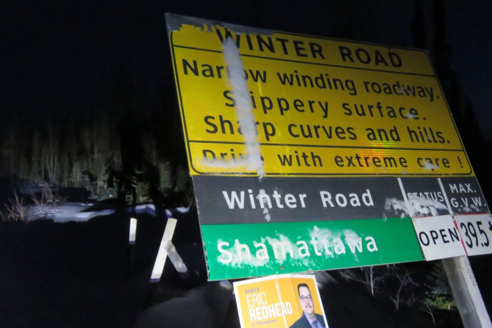
The challenge begins the next morning with newly fallen accumulated snow, there’s some apprehension, as we are alone entering the black hole of wilderness that lies ahead.
It’s dark when you come to the teetering signs. There are no tire marks ahead a plain sheet of white paper, with little margins.
There are yellow and orange signs, the first: WARNING – Winter survival and communication are recommended. Sign two: Narrow winding roadway – slippery surfaces – sharp curves and hills – drive with extreme care! (sic).
Maybe a trip to Cuba or Mexico could have been an alternative trip…”nah, that’s not Canadian.” We have to dig in our heels for a bit. We have chosen Hudson Bay instead of beach front.
We are learning – it is like those “back in the day,” Grade 8 social studies textbooks – chapter after another. It is a Canadian reality, a look at this vast and magnificent country we reside in and don’t really know until we journey across in all directions.
Stay tuned for the trek next week as our sense of patriotism is verified by geography.
In preparation, this map will help to locate the communities en route and all the way to Peawunuck and back, more than 6,000 km (4,000 mi) from Timmins-return.
It takes time to get somewhere special. Did we see polar bears?


