The MNRF is reporting 29 fires are considered out of control in the Northeast as of late Tuesday night, while 37 blazes are considered being held, under control or being observed.
While the Temagami threat was reported as stabilizing, more fires have been reported to have started up on Tuesday.
See related: Temagami area fires continue to rage in back country
New fires in the North Bay area include:
- North Bay 74, a 1.5 hectare fire located northwest of Driftwood Lake, approximately 3 km south of the Temagami Access Rd.
- North Bay 75 is located west of the Obabika River. It covers 6 hectares and is not yet under control.
- North Bay 76 cover 0.1 of a hectare is located southeast of Perch Lake, approximately 15 km southeast of Mattawa.
- North Bay 78 is located just north of Hwy 533 northwest of Mattawa. It is 0.1 of a hectare and is not under control.
Ontario is planning to deploy incident management teams over the coming days to manage priority fires. Details will become available later this week.
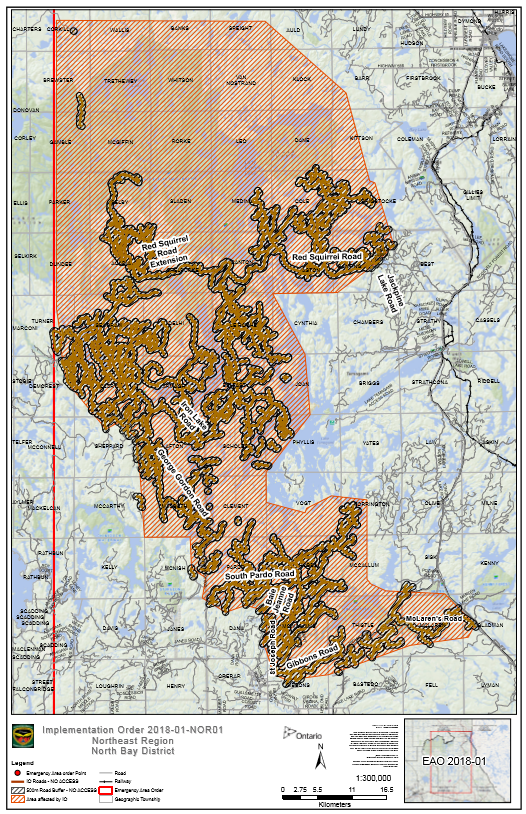
Meantime travel restrictions continue in the Temagami region due to the forest fire threat near that community North of North Bay.
The Ontario Ministry of Natural Resources and Forestry is advising the public that travel restrictions have been implemented in McLaren’s Road, Gibbons Road, Baie-Jeanne Road, South Pardo Road, and St. Joseph’s Road including George Gordon and Iron Lake Road, Red Squirrel Lake Road beyond the Jack Pine Road intersection and all access into Lady Evelyn-Smoothwater Provincial Park in the North Bay District.
Access to these areas is restricted and road blocks will be set-up to notify the public of the closure. Travel restrictions are in place and permits are required to travel through this area. Within the area, no Crown land camping, no day trips, no hiking, no ATVs and no access to private camps or cottages are permitted.
MNRF officials say this measure is meant to protect the public and ensure public safety while allowing fire personnel to safely fight forest fires in the identified area.


